Dieser Artikel ist auch in deutscher Sprache verfügbar: Zum deutschen Artikel.
At the end of July, Leipzig’s city administration submitted a proposal to the city council that is set to cause quite a stir. Not only for political groups that are not particularly keen on environmental protection, but also for departments and agencies for whom the city’s unspoilt natural environment is still a bargaining chip that can be sacrificed to ‘economic interests’. The proposal in question is the ‘Green Masterplan – Leipzig Green-Blue 2030’, which has essentially been in the works since 2017.
And whose findings have surprised quite a few experts, at least within the lead department, the Office for Urban Greenery and Waterways. The fact that some of the city’s departments have treated the green oases within the urban area so negligently is also down to the lack of up-to-date monitoring and assessment of all those pieces of the jigsaw within the city that, in their respective locations, have made life in the increasingly hot city a little more bearable. And continue to do so. Not to mention a vision of just how much green space Leipzig actually needs to remain a liveable place in the face of future extreme weather events.
“Particularly with regard to the quantitative and qualitative state of the green-blue infrastructure, there is still a lack of consistent monitoring,” the Office for Urban Greenery and Waterways (ASG) therefore notes in the draft master plan. “Transparent and easily comprehensible criteria are just as important for this as time-series-based reporting, which takes into account the longevity of green-blue ecosystems whilst also helping to identify processes that can be managed.”
An unavoidable need for action
Yet even at city level, it has been clear for years what this is all about. Namely, it is not about the pointless compensation of destroyed biotopes somewhere outside the city limits. After all, such measures have no impact on the people of Leipzig.
The draft explicitly emphasises this: “It is not only the city’s dynamic growth, but in particular the numerous environmental challenges that highlight the urgent and unavoidable need for action. Extreme weather events such as the heatwaves and droughts of recent years, on the one hand, and regular heavy rainfall or flooding, most recently in 2013, on the other, highlight the urgency of taking action. Added to this is the ever-increasing decline in biodiversity. This need for action is exacerbated by the increasing use of land for construction projects as the city grows. Consequently, previously undeveloped land, brownfield sites and vacant plots are being developed for housing and further commercial developments.
Redensification in inner-city neighbourhoods and the development of previously unused or derelict areas are putting pressure on urban open spaces and ecosystems. At the same time, the number of users of the remaining spaces is rising, particularly in the landscaped green spaces and open spaces available for public use, such as parks and green spaces, town squares, and play areas, football pitches and exercise areas. Here, the pressure of use is constantly increasing, leading in some cases to overuse and conflicts between different user groups.”
More green spaces for the city
At first glance, this sounds as though the city’s master plan is simply aimed at salvaging what can be salvaged and curbing urban sealing to some extent.
v
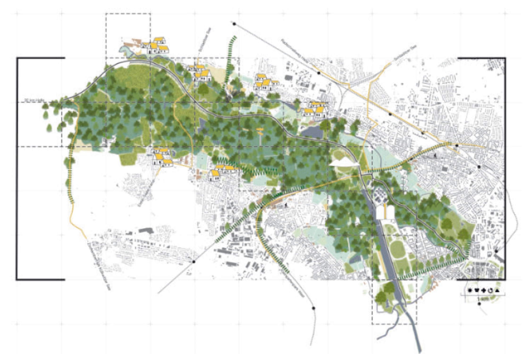
However, the master plan shows the opposite: the proportion of green space must increase significantly if it is to have any effect at all. And this must happen above all along ‘landscape corridors’, as the master plan puts it. These landscape corridors already exist – but they are constricted, fragmented and eroded. In many places, they have been so thinned out that they can no longer fulfil their function as a key landscape feature. This is particularly true of the Elster basin and the Kleinmesse site. Precisely where the city’s Land Registry had the audacity to put a 3-hectare copse up for sale.
In the master plan,
this area forms part of the so-called Elster-Luppe line. And the text on this is clear: ‘The backbone and the most valuable part of Leipzig’s green space system is undoubtedly the floodplain forest of the Weiße Elster, Pleiße and Luppe – unique in Europe – which runs right through the heart of the city. The northern floodplain forest in the river and stream valley of the Elster and Luppe can be roughly divided into two distinct sections in terms of its natural landscape and land use, with the course of the Neue Luppe forming the boundary. To the south of the river lies the actual floodplain forest, which is highly worthy of protection but seriously endangered.
To the north is a more structurally diverse area comprising grassland, wooded areas, pastures, parks and allotments. A differentiated approach to maintenance and land-use zoning for the two sections of the landscape is recommended. The Elster-Luppe route connects the floodplain forest with the Rosental and the Promenadenring. The aim of the proposed route is to improve access and wayfinding.”
High time for investment
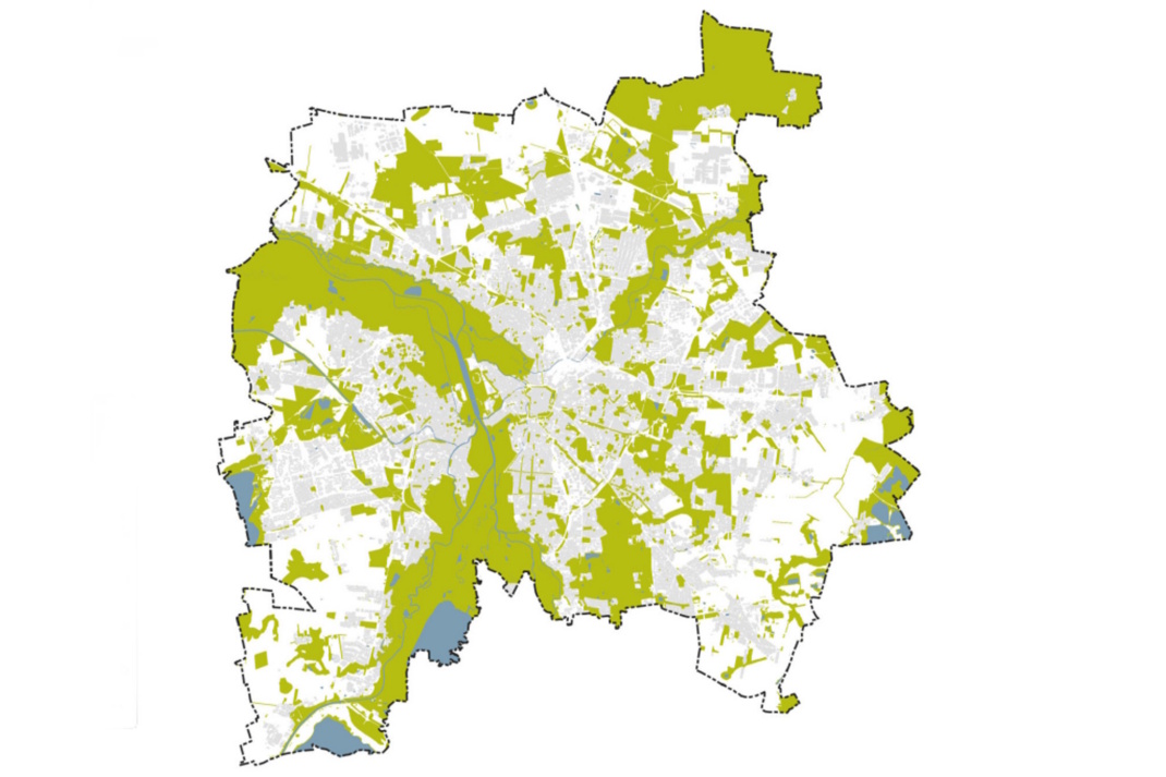
Anyone looking at the relevant map of blue-green infrastructure (see above) will see that it is precisely the area around the Kleinmesse and the small wood on Capastraße that is to be enhanced, not cleared. This is the narrowest point along the Elster-Luppe line.
This becomes even clearer when looking at the landscape development map, where this very bottleneck in the floodplain area is marked as significantly wider, because more – not less – green space urgently needs to be created here.
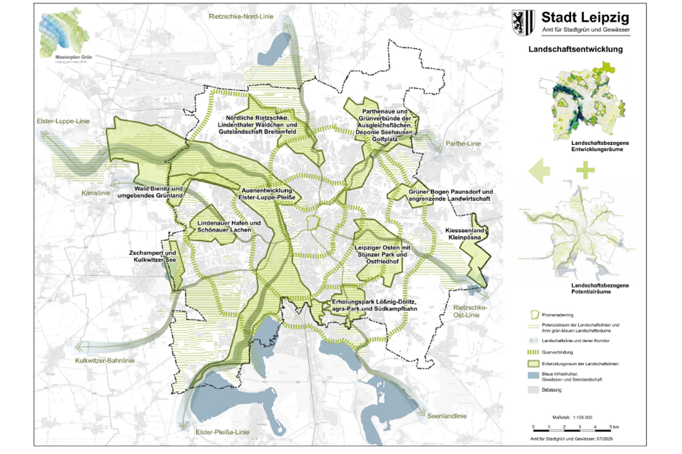
Map of landscape development showing the designated development areas for the landscape corridors. Map: City of Leipzig, Green Master Plan – Leipzig Green-Blue 2030
The draft states the following regarding this map: “Action Area II, ‘Development of Open Spaces’, together with the two map sets ‘Landscape Development’ and ‘Key Areas for Dual Internal Development’, forms a spatial framework and a network structure for the development of Leipzig’s open space system. On the basis of these two map sets, all future measures aimed at enhancing existing open spaces to form a sustainable network of green-blue infrastructure – in line with a targeted and resource-oriented approach – are to be concentrated within this spatial framework.”
This means that tangible investment must finally be made in blue-green infrastructure
so that these network structures can be strengthened. One of these building blocks is the floodplain development concept
, which is still pending
.
But at the same time, the word ‘investment’ serves as a reminder that virtually all local authorities in Germany are currently being deprived of precisely this ability to invest, because they are being suffocated by mandatory tasks imposed by the federal government for which no adequate funding is provided. This stifles not only the municipalities’ ability to act, but also democracy itself. For it is at a local level, in their own city, that people experience whether their society is still capable of taking action. Or whether even valuable green oases have to be sold off because the city is up to its ears in debt.
The debate on the master plan is likely to be fascinating. And it should also reveal which political groups have now realised just how fundamental climate protection and biodiversity conservation are for a city like Leipzig, if life there is to remain liveable in the near future.
Empfohlen auf LZ


So können Sie die Berichterstattung der Leipziger Zeitung unterstützen:




There is one comment